New road sensor station helps determine local weather-related closures
 Brookhaven, GA, Oct. 9, 2019 - “Due to inclement weather, schools (and/or businesses) will be closed tomorrow.”
Depending on the perspective, making this important judgment call can have a dramatic impact, especially during metro Atlanta’s unpredictable winter weather. For students, it’s usually met with joy in anticipation of a school “snow day,” while for businesses it can have dramatic financial consequences.
In the past, Brookhaven officials often depended solely upon the Georgia Department of Transportation (GDOT) and National Weather Service for the latest forecasts, but now that timely information will also be available closer to home.
In a unique municipal partnership with GDOT, the City has installed a Road Weather Information System (RWIS) at North Druid Hills and Buford Highway, one of the busiest intersections in Brookhaven. These systems are usually located along local state highways, but, for Brookhaven, the closest sensors are at I-400 and Pitts Road to the north and on the downtown connector near Georgia Tech to the south (the only sensor previously inside the perimeter).
“We looked into installing the RWIS because the decision for winter operations and government closings is often influenced by road conditions, including the actual road surface and road sub-surface temperatures,” said Brookhaven City Manager Christian Sigman. “GDOT’s road sensors are mostly on interstates, and road sensor data from highways does not translate well to local street conditions. Knowing exactly what is going on with the roadway is the key to successful decision making.”
The approximate $50,000 cost for the RWIS was split with Brookhaven buying the equipment and GDOT shouldering the installation cost and ongoing maintenance. The location for the system was determined by the high traffic count in this area and the lack of overhead tree canopy that could impede the station’s measurements.
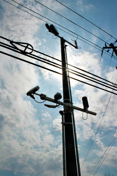
Components of the system, mounted inconspicuously on a utility pole in the North Druid Hills right-of-way, consist of a communication system enclosed in a weather-proof metal box; thermometers (for measuring air, surface and subsurface temperatures); a heated ultrasonic wind sensor (for measuring wind speed and direction); a heated visibility sensor (for detecting fog and smoke); and a barometric pressure sensor. All aerial devices are mounted high on the pole to get the best readings possible, with additional sensors embedded into the street pavement at the bridge.
A RWIS provides valuable real-time data on weather factors including pavement conditions, precipitation amounts and visibility. It can determine if it is raining, snowing or sleeting, which can create hazards for drivers. Additional information available from the sensor station includes wind speed and direction, air temperature, humidity levels, and visibility.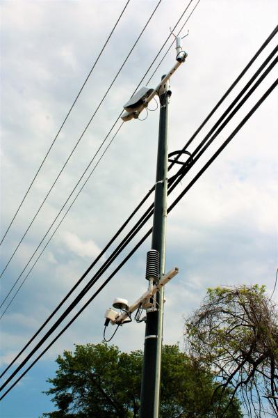
So why is this data important and necessary? It can play a role in a number of decisions such as proactively treating the roads, determining how quickly to mobilize street crews, alert the traveling public and encourage drivers to slow down in heavily affected zones. In more extreme conditions or other times of the year, the sensors can determine the need for fog or hydroplaning alerts due to severe weather.
“Members of Brookhaven’s public works, police and emergency services will be trained to monitor the RWIS data system,” noted Paul White, Brookhaven Emergency Management Coordinator. “This information is critical year-round for reliably monitoring conditions from winter ice and snow storms to spring and summer flooding, hail storms, etc.”
Anyone can access this data as well. All you have to do is go to https://www.weather.gov/ffc/gdot_rwis to find a map of all area road sensors. Zoom in to Brookhaven, and click the green dot near North Druid Hills Road and I-85. All of the charts and tables will then show data for Brookhaven’s road surface and subsurface conditions in 10-minute increments.
Since air and pavement temperatures can vary as much as 20 degrees, the valuable information gathered from the RWIS will primarily be used to determine if weather conditions warrant the need to close city facilities. It can also be used to decide how many street crews are needed at any given time, reducing associated costs by deploying only enough people needed to do the job (de-icing, sanding, what type and amount of melting agent, etc.).
In addition to making winter operations more efficient, the data can also be used throughout the year to support construction activities, timing of road maintenance and incident management. Brookhaven’s data is also readily available for science classes for weather-related projects.
“The information that will now be available on a more localized basis will help us to efficiently maintain and operate our City transportation system,” Sigman added. “Just because it may snow does not necessarily result in school or business closures. It should make those 4 a.m. judgment calls a bit easier to make.”
The new RWIS is located on the south side of North Druid Hills Rd., near I-85 and Peachtree Creek.

Anyone can access this data at https://www.weather.gov/ffc/gdot_rwis. At that link, zoom in to Brookhaven, and click the green dot near North Druid Hills Road and I-85 (as shown above) to see charts and tables with Brookhaven’s road surface and subsurface conditions in 10-minute increments.